Monday, August 27, 2007

Why I dread getting my oil changed


For some reason I dread getting my oil changed. It was that time of the year yesterday. Well I should say one of the 4 times a year that I should get my oil changed-all things being normal. I was actually 3 weeks overdue for it, but I've been gone the past 2 weeks, so this was the weekend to get the dirty deed done.

Even the fact that I had a coupon for a free oil change didn't brighten my mood either.

I even told myself that if there was a line I wasn't going to do it. But luckily (or unluckily) there was no line.

So, on Sunday, around 3pm, I went to the Jiffy Lube on Route 2 to get my oil changed in my 2005 Dodge Neon SRT4.

As soon as I pull up, the oil dude starts eyeing my car.

When I get inside the waiting area I hear him drive into the garage. By hear him, I mean not only do I hear my dual exhaust, I hear many revs followed by the pshhhhhhhhhhhhh sound of the Mopar Blow off Valve I have installed. Every time I go to Jiffy Lube they make a point of revving the engine as many times as they can!

After a few mins they call "Dodge Neon" and I walk outside to talk to the dude.

"You going to keep using Synthetic?" he asks me.
"Of course" I say.
"This is a nice car you got here."
I nod my head. "Yup."
"Its a turbo isn't it?"
"Yes it is." Did he read that off my windshield sticker or actually check out the engine?
"You got a blow-off valve don't you?"
"Yes I do." What gave you that idea?

Then he tries to sell me on the usual stuff-new wiper blades, radiator flush, tire rotation, etc. No thank you.

Twenty mins later they are actually done. They usually only take 10 mins, but it looks like they had the usual Sunday crew they used to give me when I managed at BK, you know, the "B" team. Out of 4 people in the waiting area with me, there were 2 complaints.

But, I guess I can't complain, I got a $50 oil change for free with the coupon, even if it means a longer wait and the crappy job they do of vacuuming, etc. I think next time I might take it to the dealership, they don't go crazy everytime they see my car...

Saturday, August 25, 2007

The Highest Point in...


Today Joy and I traveled to the highest point in RI at a whopping 812ft above sea level. That place? Jerimoth Hill in Foster. There's a sign by the side of the road and then a two mintue walk (a 5 foot elevation gain-whoa!) and you are at the actual spot/rock which has a small cairn stone at top. There's also a mailbox with a notebook that you can sign, which Joy and I did. At the spot where the rock is, there is a small clearing with a few sheds and a telescope pad and at the point the property is owned by Brown University. The path to get there however is private property. Strangely enough, for the longest time (until 2005 I think) it was almost impossible to get to the actual spot because the owner(s) never let anybody!!

Anyways, I've now been to the highest point in 2 states! (NH and RI) It would be fun to join the Highpointers Club, climb the highest point in each state, however thats a lot of Mountain Climbing, Alaska's Mt. McKinely being the highest at 20320 ft.

The clearing at the top of the "hill"


The trail that we "hiked" to get there


Me at the unofficial highest point (actual spot is mere 5 feet higher)


The wife at the actual highest spot in RI

Tuesday, August 21, 2007

Eat cold steel!

Just got my 2007 COLD STEEL product catalog in the mail. You know, the makers of knives, more knives, swords, throwing knives, etc, etc? That Cold Steel. It also came with a DVD that showcases how good their swords really are. I want a sword. More knives would be fun too. Maybe some more throwing knives (since somebody lost one of mine...) But yes, thats s-words. These are words that begin with the letter S. I think I'm going to try and talk my wife into getting me a sword at King Richard's Faire this year. The talk was unsuccessful last year, but it might work this year! If not, kettle popcorn and seeing the Liger is always a lot of fun...

Monday, August 20, 2007

An adventure to remember...


The following is the true story of two brave men who against all odds attempted to climb to the summit of Mt. Washington, an elevation of 6288 ft above sea level and home to the "Worst Weather in the World", on Saturday, August 18th, 2007.

The story starts out a few months ago when I ask my Dad, then a month away from turning 50, when we are going to climb Mt. Washington, the tallest peak in the Northeast. We set a date for the weekend of August 17th and asked our family members if they would be interested in making the hike with us. At first it looks like my sisters Beth and Kelly, along with Tim, my brother-in-law are interested, and perhaps my Brother Kyle. But as the week approaches (and my dad turns 50) they all back out for whatever reason. But that doesn't stop my Dad and I-we are going to climb the mountain no matter what. We would later come to find out just how true that statement would be.

We end up staying at the Bretton Woods Lodge, a motel of sorts, across from the famous Mount Washington Hotel. The location is ideal because it is 10 mins from the trail head and has a jacuzzi. Score. It is around four hours to the "Lodge" from Woonsocket, RI and after having some incredibly spicy buffalo tenders from the Tiverton Diner, we make it to our room by 10:30pm. We make it to bed a little after 12, thank you Gagne for blowing another game for the Sox!, and enjoy the "calm before the store."

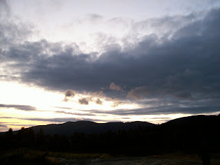
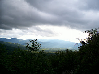
As we wake up the morning of the 18th, the sky is overcast, cloudy, and lightly raining (mind you the forecast was sunny and warm). As you can see in the picture at the top, the mountains are covered in clouds and fog. Its about 65 degrees out. It doesn't matter though, we are going to hike anyways, even if we can't see where we are hiking to.

After the always interesting Continental Breakfast full of carbs, we get our gear and drive over to the trail head making it there around 9. The trail head for the Ammonoosuc Ravine Trail, which we are taking up, is right below the Cog Railway station, where I buy a map and trail guide. We actually didn't start at the official trail head, but at the station, elevation 2600', on a trail the leads right into the Ammonoosuc. (The trail head is actually a 100' lower)

Now, this being Mt. Washington, home to the "world's worst weather", we were packed a little more differently than when doing Monadnock. It doesn't snow on the summit in Summer at Monadnock. We each had brought gloves, pants, extra socks, jacket, and my Dad packed an extra hat and fleece pullover. Plus we had all our usual gear, plenty of food and water, first aid, flashlight, map, compass, knives, etc. As it was raining lightly when we got there, we each wore hiking shoes, shorts, t-shirt with a jacket over it.

So with all that being said, we started out on the trail around 9:14 am. I calibrated my Suunto Vector and started the log. The goal was to take the Ammonoosuc Ravine Trail up the Lake of the Clouds hut at an elevation of 5050 ft. The distance to there was 3.1 miles with an elevation climb of 2500'. After that we would take the Crawford path another 1.4 miles to the summit (6288') for a total distance of 4.5 miles and total elevation climb of 3800'. The trail guide estimated that it would take 4 hours and 10 mins to make it to the top by this trail. But of course that doesn't account for breaks, bad weather, wet rocks etc.


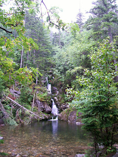
The trail itself was exactly what I was expecting. It has so much more of a "wilderness" feel than the trails at Monadnock. The trail is usually only wide enough for two people at a time, and followed a small river, complete with waterfalls and small pools, for most of the beginning of the trail. Above is a picture I took where the trail crosses over the river (one of several times it does so). We hiked at a moderate pace, seeing numerous groups of people, even kids and dogs. As we hiked up, it was still wet and raining, so you always had to be careful on rocks and logs and when crossing streams and such. During the hike there were many spectacular views, however I hardly took any pictures. It was great to look out a clearing and see nothing but fog and clouds! That's right, as we were hiking up, we were constantly staring at clouds and fog. And when you take in the fact that it was raining and foggy, with water everywhere, it was not easy taking a picture.

The hike below the treeline was fairly nice. Well it was more like OK, because of the rain, fog, clouds, and the fact that my Dad's right contact kept on slipping off his eye. At one point, there is the Gorge, where there is a nice waterfall, that falls 600 ft, but we didn't stop to see it. I was able to traverse the trail with no hands, my speciality, for most of the trail until we got to about 4000', just below the treeline, where there are several spots where you have to climb up steep, wet, rocks. It was also at this point that I put on my gloves as the weather was getting colder. A few hundred feet before the treeline we crossed over a river, where if the river was a little bit higher, we would have gotten our feet wet.


As we approached the treeline the wind really started picking up. As we passed into the alpine zone the weather really started getting worse as there were no trees to protect us from the brutal wind. As we neared the Lake of the Clouds Hut the wind would literally push us up the rocks we were climbing, prompting us to use our hands to steady ourselves on wet and slippery rocks. My hat kept on getting blown off my head. It was pretty crazy out there, especially since we still had shorts on. Yet the worst was yet to come! We made it the hut around 12:30-I remember being right outside the hut, and trying to walk to the right and getting almost blown over by the wind several times before I finally was able to make in the door of the hut!

We stayed in the hut getting warm and a "slightly" drier, eating some food and drinking water. The hut is pretty cool, they have bunks and you can stay there overnight. They also have a kitchen, small store, and running water (no flush toilets though). The hut is absolutely crowded with people taking shelter from the crazy mountain weather. Mostly everybody who made it to the hut is turning around and going back down the mountain. Nobody is crazy enough to try to reach the summit when they know the weather is just going to get worse as they climb up. Not to mention they have the summit weather conditions posted.

It doesn't matter to us though. We are going to the top. We decide NOT to put on our pants. We bundle up tight, and head outside. The wind has really picked up. As soon as I step outside my hat almost gets blown into oblivion, so I have to put that away. After about 5 feet, my glasses become useless because of all the moisture in the air, so I put them away too. That's right, I have to hike the next 1200 feet without my glasses, good thing I'm not totally blind. To complicate things even more, it starts hailing, the temperature is down to 45 degrees (before wind chill), and the visibility is so low that we can barely make out the next cairn stone in front of us. (Above the treeline all you really have are cairn stones to guide your way) The wind is blowing so hard that every step we take we have to steady ourselves with our hands. My nose is running like crazy. The wind is so strong that it blows the snot dripping from my nose in a long string 10 ft away. I kid you not. If I didn't sniffle, the snot was flying far away, it was that crazy.

It also didn't help that by this point my shorts, jacket, t-shirt, and gloves were completely soaked with water. My legs were also red from all the hail. The wind was so powerful that I took my gloves off for a split second, and immediately, my hand felt like it was being stabbed by hundreds of sharp icicles. As I approached the last stretch, perhaps a half hour from the top, my hands started going numb. My hands are always cold, not to mention that they are in gloves that are soaked, but to take off the gloves would definitely mean frostbite. Also, I started losing the feeling in my legs. This was something new. My legs were doing most of the work and I couldn't even feel them! This was definitely not good.

At this point in the game, I needed to make it to the summit before I froze to death. The feeling in my hands and legs were starting to drain fast. If my hands were gone, that was okay, but if my legs went? That would spell near death. I actually went ahead of my Dad and pushed onto the summit by myself, although he was never more than a few minutes behind. Visibility was so low that the rest of the way to the peak I had to stop at every cairn stone and figure out where the next cairn stone was. This was no easy feat because standing still was almost impossible with the wind and hail still pelting me. Several times I couldn't see the next pile of stones but was able to go in the right general direction. If I had missed the path at any step and couldn't find my way back...well lets just say I wouldn't have lasted long wandering around in that weather...

Soon an ominous building loomed in the distance, and as I staggered towards it, I let out a shout of triumph! The path ended up turning right, around the building, past a stone wall, and onto the summit. I had made it!

But wait, where do I go now? I'm not inside yet! There's a giant weather tower thing to my right, and two buildings to my left. The first building says "Authorized Personnel Only". Crap, am I going to make it the top then die because I have no idea how to get inside? I spot a group of four other hikers who are as clueless as I am. I head towards them and climb up the actual tallest point on Mt. Washington where the sign is that says 6288 ft. I somehow manage to take a picture of them, despite feeling extremely cold-dangerously cold. They finally figure out how to get inside, which is around the side of a long building, and we run inside, safe at last. Turns out my Dad was there waiting for me. Where were you he asks? Oh, just at the real summit!

So we are inside, and safe...well not quite yet! We take of our jackets and packs and I'm shaking. I take off my shorts, which are completely soaked, and put on my sweatpants, which are the ONLY thing dry in my backpack. I start shaking more. I proceed to the gift shop where I purchase a fleece pullover and put it on. But I'm still shaking. I buy some chilli and hot chocolate, nearly spilling the hot chocolate because I'm shaking so much. Why am I shaking? Because my body is trying to fight off hypothermia, that's why. While I was hiking up, my legs and hands were going numb because my body was trying to draw heat back into the core of my body. The shaking is one of the body's last attempts to generate heat. The problem is that the shaking usually uses up ALL of the person's last energy and they end up dying soon after that.

Luckily the hot chocolate and chilli give me enough energy and help me to warm up and stop shaking. Crazy, crazy stuff. Another half hour out in that cold and I would have been all done for. (Hypothermia is very interesting, the thing to do is get out of wet clothes as soon as possible and eat high energy foods like candy bars etc. Also be on the lookout for your party members because it can cause you make bad decisions and refuse treatment.) Also crazy is the fact that my Dad was shaking too! He never gets cold, and he had a shirt, fleece, AND jacket on. Crazy. We spend an hour getting warmed up and relaxing. We had got to the summit around 2:15 I think.


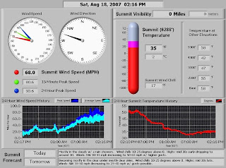
Above is the actual data posted at the time we were at the summit. Wind speed was 68 mph. Insane. Gusting up to 80 mph? Double insane. That's hurricane force winds. Not to mention the temperature of 35 with windchill of 17. Summit visibility? 0. Excellent. Not on the picture was the humidity, which was 100%. You would have to be insane to hike in that kind of weather!

People that came up from the Cog or Auto Rd are stepping into the area where I am after getting off a shuttle and complaining how cold and nasty it is outside! Buddy, you were outside for 2 seconds!!! I just hiked up here!!! See me? I'm still shaking from the cold!!! Other people who managed to hike up as well are purchasing one way cog railway tickets to go back down or trying to get on one of the shuttles!

We have to finish what we started though, so we are hiking all the way back down. First though, we have to buy some more gear because all our old stuff is soaked. My gloves and hat are useless so I have to buy new wool gloves and a wool hat. My Dad does the same but also has to buy a new jacket. We also buy ponchos. Needless to say, the gloves/hat are now staying in my pack, and I will be putting everything in plastic bags so that they don't get wet again. (Walking through fog with 100% humidity doesn't help things either). We know that the worst is over, and that as we descend the weather can only get better and warmer. We leave around 3:15 and start the long journey down the mountain.

This time we have pants and wool gloves and hats and are relatively dry. We are rested, but the cold has sapped some our energy, and after a 4.5 mile hike up the mountain, most people are tired regardless of the weather. We were originally going to take the Gulfside trail to the Jewell trail down, which is a lot less steep, but a little longer at 5.1 miles with total a descent of 3900 ft. However, because of the 68 mph winds, we had to modify our plans a little. The gulfside trail actually travels along side a cliff and is a little bit dangerous because of the very, very strong winds. So, the park ranger suggest we cut that bit out of the hike. What we will do is travel down the way we came up until we come to the Junction for the Gulfside trail. We will follow that trail till it crosses the Cog railway, follow the rail down until it intersects with the Gulfside trail again, then follow that until it turns into the Jewell and take that all the way back down. This will cut out the crazy winds on the cliff (and North side of the Mountain coming off the summit).

Coming out of the summit building, I'm nearly blown off my feet again as my Dad takes a picture of me. (I go without glasses again) We travel back the way we came and the wind this time was coming at us, attempting to push us back up the mountain. Luckily, the hail had stopped and visibility was a tad bit better. It was still crazy just trying to get down the summit "cone" and to the first junction. The difference in wind just from getting off the cone to the first trail junction was incredible. The distance was less than half a mile and a hundred feet down.

We make it the cog and follow that down on a clear dirt path where they are supposedly building new power lines or something. This is not bad, expect for the fact that the wind is still blowing in our face. At several points we can hear and smell the cog, but can never see it, because its still too foggy. We follow the cog for a bit before we pick up the Gulfside trail again. This trail is really rocky, so we have to go back to climbing down with hands and feet. We are not rushing at this point, but keeping up a good pace. Well, it is actually a fairly slow pace. We are both getting tired and sore. My hips hurt at first, but then it is my knees as well as my shoulders. (Carrying lots of wet clothes is not good) My dad says his knees and back hurt. We finally make it the Jewell trail and the treeline, which finally means respite from the wind (and me being able to put my glasses back on). What a difference trees make! The Jewell at this point starts doing this switchback kind of thing, which we don't really like, but it turns out the trail is a lot less steep than the one we came up.


Finally, around five, the fog clears out for the first time all day and you can see the valley! The picture above is one I took for the few mins the fog cleared out. You can actually see that the fog and clouds still surround everything except for that patch of sunlight-an amazing sight! Well, we continue to climb down, it is not much warmer down here, but it is not as windy either. I wear my gloves and hat for most of the summit down.

The trail doesn't seem to end though, it is getting close to 7pm, which means almost 10 hours of hiking! At one point I see a worn sign that looks like it says Couger R., which I take to mean couger rock (which I don't remember being on the map), and we ignore it and keep on going on the trail for what seems like forever. Finally I see a sign that says "base station .3 miles". I end up getting a second wind and power walk the longest .3 miles in my life and finally make it to the road!! Wait, this is not the parking lot! We then proceed to walk an extra 15 mins to our car as the sun sets.

Did you figure out what Couger Rock was? It was a sign for Cog Railway I suspect. The sign was so worn that I couldn't make it out! If we had took that side trail we would have saved an hour! Bummer!!!

Regardless, the entire trip turned out to be 10 hours and 46 mins! About 9.6 miles distance, and total elevation ascended around 3960 ft. In the end, we made it to the top and back, fighting below freezing temperatures, hurricane force winds, hail, and hypothermia, and conquering the majestic and dangerous Mt. Washington.

We made it back to the Motel, ate a nice warm meal, and relaxed in the jacuzzi (which really helped) and slept good that night!!

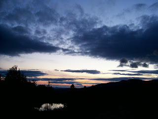
Here's some pics as the day ended:


Thursday, August 16, 2007

Last day


On our last day we wake up late and I get to eat eggs and bacon again. Yummy. Camping is great!

After two good days of hiking, today we only do a short hike up the halfway house trail, so named because its halfway to the top and the site of a once famous hotel. Now it is just ruins, but there is still the road that runs up to the spot, parallel to the trail, and there is a private house at the end of the road (see pic. I wouldn't mind living up here!)

The hike doesn't start from our campsite-we have to drive to another spot to hike, which when looking at the mountain is the gently sloping side of the mountain. That being side, the hike is fairly easy, not steep at all, although I still am feeling it from the past two days of hiking. We only have to climb 500 ft and we make it to the ruins in 45 mins, eat our lunch, and walk the dirt road down, getting back in 35 mins. A nice quick hike, which is good, because we must leave that night : (

Back at the camp we play some more scrabble, and slowly pack up (sadly), but of course we make one more fire, with much trouble. Maybe someday I'll learn proper fire making techniques. Ha.
We leave the camp around 6:30, but make sure to stop and get ice cream on the way home. Have to have ice cream!!! A nice way to top of a good weekend of camping and hiking.

I just hope I will be ready for Mt. Washington this weekend!!

Here is what I learned on this camping trip:
Birch bark is excellent tinder
That being said, I still suck at making fires
Make sure Joy brings camera next time! The treo doesn't cut it (sadly)
Joy is really good at folding tents/canopies/tarps/maps etc, its exactly why I brought her along! J/k-I love you babe!
My new watch is pretty sweet, we'll see how the Suunto Vector stands up to Mt. Washington.
Ice can last a long time if properly taken care of. We still had a bunch of ice in the cooler when we got home. We put two bags in fri. morning and it lasted until late Sunday night before we dumped everything out.

Next year we are going to do an actual overnight (2-3 night) backpacking trip. Mr. Army, Kyle, my brother, wants in, so we'll see if he'll be up to it by then!

Day number 2


Saturday my wonderful wife cooked me my favorite Dunkin Donuts breakfast minus the dunkin donuts. She made me a bacon, egg, and chz on a cinnamon raisin bagel on the stove!

Hiking wise, we decided that we would not head UP so much, but instead head AROUND the mountain. According to the Map it would only be a 1000' elevation climb up, then 1000' down and then the same back. I estimated that it would be around 2.2 miles one way and was thinking it would only take us under 3 hours total. So we took the white dot trail, to the Cascade trail, to the Birchtoft trail (full of lots of birch trees naturally) which ended up at Gibson Pond.

The hike was a lot different from all the rocks you encounter going up the mountain. Instead, you walk on fallen leaves and pine needles, and over fallen trees and such. It reminded me of the woods in back of my parents house where I grew up-a very beautiful forest scene indeed.

Remember how I thought the whole trip (one way) would only be 2.2 miles? Well it turns out that the birchtoft trail itself was 2.2 miles, making the whole trip one way over 3 miles. Now, you might think, what is another mile? 2 or 3 miles is not big deal. Well it IS a big deal when you hiked a mountain the previous day and you are a little sore and you are hiking with a pack. Nonetheless we make it to the end of the birchtoft trail after about 2.5 hours. Looking at the map, we see that you can walk a short distance from the end of the trail and be on the main road, which would lead us back to our campsite. We decide, we might as well just walk the road back, it will be nice and easy and not so much up and down, and save us some time.

But of course there was some exploring to do first. We walked up from the trail to what turned out to be a construction site. There was a dirt road that lead down the site a little bit and we decided to follow that to see where it led, and thinking it would probably lead to the main rd eventually. After a few minutes we came to a path in the woods, with no sign or markings. By this point we were off my map, but what is camping without doing a little exploring, right? Of course Joy doesn't want to see where the path leads, she wants to start heading back to camp. I somehow convince her that we will just follow the path for 20 mins then head back.

I am glad we decided to take the path because we saw some interesting stuff. The path was single file and didn't look like anybody had walked on it in quite some time. There were lots of fern bushes and we crossed over 3 little bridges over little brooks. 3 different bridges-one was perfect, the second one had one broken plank, and the third was completely rotted but there was a pile of new wood right by it. There are plenty of forks in the path, but we always take the right fork, so that on the way back we can just take the left fork. No point in getting lost when these trails are not on my map! We did see a few signs saying XC-39 (or another number), which we think are for Cross Country Skiers, but are not sure. After almost 20 mins the path doesn't really lead us anywhere, so we head back.

On the way back I spot what looks like a small stone building on top of a hill that I hadn't noticed before. That is interesting. I climb up and find a stone chimney/fireplace structure, surrounded by evergreen-type trees, and in front of the fireplace, a wooden structure. You can see it in the picture at the top of the post. It is like a little lean-to, and the wood is held together by rope. I remember reading about that in the army manual. Very interesting, considering we are in the middle of the wilderness in NH and this little hideaway is on top of a small hill, surrounded by trees, barely visible from the path...

Well we finally make it back to the main road and walk the hour back to the campsite. 1 hour beats 2 hours hiking back mind you. Somebody did actually stop and ask us if we were lost and wanted a ride back, but I declined of course. So the total hike turned out to be 4 hours long and interesting enough. As soon as we got back to the campsite, we hopped into the Cruiser and had a wonderful camping dinner at Taco Bell back in town. Yummy taco bell. Mmmmmmmmmmm. Nice and easy cleanup!

Back at the site, round 2 for trying to get a fire going. Joy wins this round as she read in the army survival manual that Birch bark is really good for starting fires, so we get a bunch of that and have the fire going in no time at all!

To repay Joy for her resourcefulness, I beat her in Scrabble, even though she uses up all her letters and I'm stuck at the end of the game with a Q. A few turns before that I had a J and an X.
Nonetheless we go to bed sore from a good hike (my shoulders especially) on a night much warmer than the last...

Wednesday, August 15, 2007

Time to climb!


But Friday was not all about being armed to survive and sitting around. No, it was about getting into the wilderness and hitting the trails. And that is exactly what Joy and I did, we climbed Mt. Monadnock.

We started out at the Park Ranger office, elevation 1400', sunny, and 70 degrees. It was a beautiful day to climb to the summit of Monadnock (3165'). We took the White Dot Trail up and down, which is the most direct route to the summit, being about 1.9 mi one way. It was not too hot, and we hardly sweat. The fact that Joy and I had started exercising regularly after the wedding really helped us out. We were able to make it up to the summit in an hour and 20 mins, and back down in the same amount of time (only stopping here and there for a few mins). At the summit it was 66 degrees and windy and fairly clear. From here, you can see clearly in all directions (supposedly over 100 miles), which gives you a vista of NY, MA, and VT. Supposedly, on a clear day you can see the skyscrapers in Boston.

For those of you who have never hiked Monadnock before, you climb up almost 1800 feet and it is not all easy going the entire way. There is a fair amount of rock climbing, not like technical climbing, but spots where you must use your hands and feet to get up. Well most people need to use their hands. I always ascend no hands, which can be done with a bit of skill if you are tall. (Does this come from always riding roller coasters no hands?) That being said, the average hiker makes it up in a little under 2 hours, but it is fairly obtainable for most people and has a wonderful view to reward you at the top.

So it was a fairly smooth hike and I was able to test out the aforementioned Suunto Vector's elevation measuring aspects. According to the watch, it was 3220 ft at the top...off by 50 feet, less than 2%, which is not bad considering I never calibrated it at the beginning of the hike. A word about altimeters on watches-no matter what brand you buy, they always have to be calibrated at known elevation points, because they measure elevation by air pressure, which changes the higher you rise. The thing is, air pressure is always changing, depending on a million different things, including temperature (which they explain in the manual), but nonetheless, it is fairly accurate, all things considered, and is very helpful in figuring out how much more you have to go, cross-referencing with topo maps etc. (Now if you bought the GPS model for $500 your elevation would be spot on accurate AND you would have GPS coordinates, but this watch was expensive enough) Also, by the watch, our rates for ascending/descending were between 0 and 27 ft/second. Just another interesting measurement to figure out how much longer it will take to get down. (The Vector can also tell you the average rate for a particular time period if you ask it, say the entire hike, it automatically records your elevation for the past 24 hours (same with the barometric readings), or it can log it and save it for future reference. And it keeps track of all your highs and lows, like highest elevation, most elevation gain, etc.)

Needless to say, I was very impressed with the watch's first real action and will definitely make good use of it on my Washington summit this weekend.

Enough about the watch.

Back to me sucking at survival skills. We are camping, and that means we need a fire to cook our hot dogs and smores over. Honestly, I'm really not sure where Smokey the Bear gets off telling people about forest fires and how dangerous they are and always remember to put out your fire etc, because I can't even make a fire when I'm trying to make a fire. Dry wood, check. Lighter, check. Firepit, check. Tinder, plenty-check. Fire? No. How about now? No. How about 30 mins later? Yes. Wow that is hard work. Smokey the bear indeed.

After dinner I take over the world.

The entire world in a night, sounds like Santa Clause, but its just Michael Thomas and global domination.

I'm talking about RISK of course.

Exhausted from taking over the world, I head to bed with Joy in our 40 degree rated sleeping bags. Wow is it cold. Rated down to 40 degrees? It is chilllllllly. We make it to sleep. I wake up in the middle of the night and check my watch, it reports that its 52 degrees. 52!! Considering our apartment has been in the 80's when we usually sleep, that is a big difference. A 30 degree difference!! Good thing I had a warm body to cuddle up to...

Why does it always rain??


So last Friday it was raining. Why was it raining? Because I was going camping thats why. For some reason it always seems to rain when I go camping-just ask Mr. Andy Clemence. So on Friday we pack the car in the rain, skip bringing the bikes (because of the rain), get the ice and my favorite breakfast meal from Dunkin Donuts- a bacon, egg, and chz on a cinnamon raisen bagel with a mountain dew, and head off in Joy's PT Cruiser to Mt. Monadnock State Park in New Hampshire.

When we get there, it is still raining, but it looks like it will clear up soon. The park is absolutely empty-no hikers or campers yet. We check in and walk around the campgrounds for a bit untill it stops raining and then we setup our gear in Thomas fashion-tent (with rainfly) ontop of the tarp, a screened canopy over the picnic table (for bug free eating), and extra tarps to cover the bikes/camping chairs and to hang with rope to go over the tent if it really gets bad. Luckily, it clears up and is rainfree the rest of the weekend.

Of course I have all my other gear with me as well. You can never be too prepared! I've got a hatchet, collapsable shovel, two machetes (ones from the Domincan Republic), multiple fixed blade knives, lots of extra rope, maglites, my two burner propane camping stove, lighters, matches, lantern, etc, etc. And thats not to mention all the gear I actually carry on me when I go hiking-my survival gear as I like to put it. More on that in a bit. This year Joy and I actually purchased "real" hiking backpacks. I got the Kelty Redwing 3100 (as in 3100 cubic inchs of space) and Joy got the Kelty Redwing 2500 (specifically made for women) and we hope to do an actual backpacking trip next year (just a few days) so these should be plenty of space. Besides having all the usual padding, straps, pouches, etc, I really like the pack because it has two spots to put water bottles that I can reach without taking my pack off, which is great for quick swigs of water when hiking. (And yes it is CamelPak compatible, but I haven't gotten into that yet)

So, as I said, when I hike, I carry my "survival gear" as I like to call it. After all, it is not the fact that you might never get lost, but the fact that IF you do you will be all set. My typical hiking clothes are a t-shirt, cargo shorts, and my adidas shoes. (I really need to invest in real hiking clothes-all mine are cotton which is about the worst thing to wear for hiking. Why? Because it absorbs moisture and takes forever to dry. Synthetics and other things actually move sweat away from the body and insulate better even when wet. But I digress) I also usually wear my camo boonie hat. Good for keeping the sun, rain, and suprisingly bugs out of your face.

In my pockets are the following:
wallet (duh)
Cold Steel Recon 1 tactical knife -spear point of course. I would love a nice ka-bar, but this thing rocks because as a foldable it fits nicely in my pocket, but the blade is still 4" long, illegal in most states. Especially RI, and I do happen to carry this knife around a lot. Can you imagine me getting arrested for illegal possesion of weapons? Now that would be funny. But yeah, this knife is great for cutting, sawing, even spreading peanut butter and jelly...
Swiss army knife You can't go camping without this just because of how much it actually does for so little space! (yes, you could always use a multi-tool, but they are a bit bigger/heavier)
Treo 700w Why? Its my phone, can take crappy pictures (1.3 MP? Still no match for a decent camera), and does lot of other things, could actually use google earth if I could find a signal...
and my new toy, the Suunto Vector Suunto Vector This thing is just sick in how much stuff it actually does. Altimeter, barometer, compass, thermometer, tons of recording logs, ascent, descent speeds, etc, etc. Oh yeah, it also tells the time, has 3 alarms, a stopwatch and timer. Yeah, this thing is sweet. This would be the first time I will be testing to see if the altimeter works though. I know the barometer works, the compass works, the thermometer works (just have to take it off to get an accurate reading-body heat). Did I say that this was a sweet watch? You get the point...

Then I have my Kelty 3100 Redwing with the following:
2 aluminum water bottles (about 28 oz of water each) You always need water
A little Suunto Compass/thermometer strapped to my pack. Not actually sure why I got this, prolly thought it look cooled.
lunch bag with lots of extra food You can't have enough snacks, including peanut butter crackers, nuts, slim jims, chex mix, etc
Rain jacket Mountain weather is unpredictable
rope You always need extra rope-thank you boondock saints!!
army survival manual Because I actually don't know how to survive, this thing will tell you how to hunt, fish, fix wounds, build shelters, etc.
map of area duh again
photon led flashlight small, yet bright
Pocket Survival Kit Its got everything you need to survive if you get lost, including whistle, duck tape, firestarter..
adventure medical kit first aid of course!
waterproof matches
bug repellant

All that is about a 12lb backpack with food and water. Which is not too bad. On saturday when I do Mt. Washington though, I'll be adding in some extra clothes, I have no intentions of being caught in a snowstorm unprepared. So thats my survival gear, but as you will come to find out, my survival skills suck!!

Monday, August 13, 2007

STILL more to come...


So Joy and I took our first post-honeymoon trip this weekend to the lovely state of New Hampshire. We drove up Friday morning to Mt. Monadnock State Park where we camped the next two nights and hiked the weekend away. More to come on all the weekends adventures and my obsession with wilderness survival!

First post!

This is the first post of my new blog! Much more to come...