The following is the true story of two brave men who against all odds attempted to climb to the summit of Mt. Washington, an elevation of 6288 ft above sea level and home to the "Worst Weather in the World", on Saturday, August 18th, 2007.
The story starts out a few months ago when I ask my Dad, then a month away from turning 50, when we are going to climb Mt. Washington, the tallest peak in the Northeast. We set a date for the weekend of August 17th and asked our family members if they would be interested in making the hike with us. At first it looks like my sisters Beth and Kelly, along with Tim, my brother-in-law are interested, and perhaps my Brother Kyle. But as the week approaches (and my dad turns 50) they all back out for whatever reason. But that doesn't stop my Dad and I-we are going to climb the mountain no matter what. We would later come to find out just how true that statement would be.
We end up staying at the Bretton Woods Lodge, a motel of sorts, across from the famous Mount Washington Hotel. The location is ideal because it is 10 mins from the trail head and has a jacuzzi. Score. It is around four hours to the "Lodge" from Woonsocket, RI and after having some incredibly spicy buffalo tenders from the Tiverton Diner, we make it to our room by 10:30pm. We make it to bed a little after 12, thank you Gagne for blowing another game for the Sox!, and enjoy the "calm before the store."
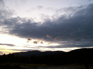
As we wake up the morning of the 18th, the sky is overcast, cloudy, and lightly raining (mind you the forecast was sunny and warm). As you can see in the picture at the top, the mountains are covered in clouds and fog. Its about 65 degrees out. It doesn't matter though, we are going to hike anyways, even if we can't see where we are hiking to.
After the always interesting Continental Breakfast full of carbs, we get our gear and drive over to the trail head making it there around 9. The trail head for the Ammonoosuc Ravine Trail, which we are taking up, is right below the Cog Railway station, where I buy a map and trail guide. We actually didn't start at the official trail head, but at the station, elevation 2600', on a trail the leads right into the Ammonoosuc. (The trail head is actually a 100' lower)
Now, this being Mt. Washington, home to the "world's worst weather", we were packed a little more differently than when doing Monadnock. It doesn't snow on the summit in Summer at Monadnock. We each had brought gloves, pants, extra socks, jacket, and my Dad packed an extra hat and fleece pullover. Plus we had all our usual gear, plenty of food and water, first aid, flashlight, map, compass, knives, etc. As it was raining lightly when we got there, we each wore hiking shoes, shorts, t-shirt with a jacket over it.
So with all that being said, we started out on the trail around 9:14 am. I calibrated my Suunto Vector and started the log. The goal was to take the Ammonoosuc Ravine Trail up the Lake of the Clouds hut at an elevation of 5050 ft. The distance to there was 3.1 miles with an elevation climb of 2500'. After that we would take the Crawford path another 1.4 miles to the summit (6288') for a total distance of 4.5 miles and total elevation climb of 3800'. The trail guide estimated that it would take 4 hours and 10 mins to make it to the top by this trail. But of course that doesn't account for breaks, bad weather, wet rocks etc.
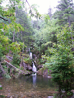
The trail itself was exactly what I was expecting. It has so much more of a "wilderness" feel than the trails at Monadnock. The trail is usually only wide enough for two people at a time, and followed a small river, complete with waterfalls and small pools, for most of the beginning of the trail. Above is a picture I took where the trail crosses over the river (one of several times it does so). We hiked at a moderate pace, seeing numerous groups of people, even kids and dogs. As we hiked up, it was still wet and raining, so you always had to be careful on rocks and logs and when crossing streams and such. During the hike there were many spectacular views, however I hardly took any pictures. It was great to look out a clearing and see nothing but fog and clouds! That's right, as we were hiking up, we were constantly staring at clouds and fog. And when you take in the fact that it was raining and foggy, with water everywhere, it was not easy taking a picture.
The hike below the treeline was fairly nice. Well it was more like OK, because of the rain, fog, clouds, and the fact that my Dad's right contact kept on slipping off his eye. At one point, there is the Gorge, where there is a nice waterfall, that falls 600 ft, but we didn't stop to see it. I was able to traverse the trail with no hands, my speciality, for most of the trail until we got to about 4000', just below the treeline, where there are several spots where you have to climb up steep, wet, rocks. It was also at this point that I put on my gloves as the weather was getting colder. A few hundred feet before the treeline we crossed over a river, where if the river was a little bit higher, we would have gotten our feet wet.
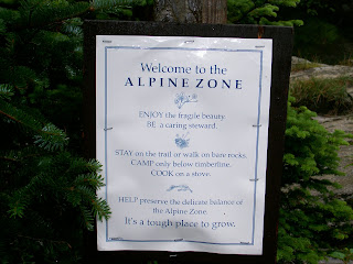
As we approached the treeline the wind really started picking up. As we passed into the alpine zone the weather really started getting worse as there were no trees to protect us from the brutal wind. As we neared the Lake of the Clouds Hut the wind would literally push us up the rocks we were climbing, prompting us to use our hands to steady ourselves on wet and slippery rocks. My hat kept on getting blown off my head. It was pretty crazy out there, especially since we still had shorts on. Yet the worst was yet to come! We made it the hut around 12:30-I remember being right outside the hut, and trying to walk to the right and getting almost blown over by the wind several times before I finally was able to make in the door of the hut!
We stayed in the hut getting warm and a "slightly" drier, eating some food and drinking water. The hut is pretty cool, they have bunks and you can stay there overnight. They also have a kitchen, small store, and running water (no flush toilets though). The hut is absolutely crowded with people taking shelter from the crazy mountain weather. Mostly everybody who made it to the hut is turning around and going back down the mountain. Nobody is crazy enough to try to reach the summit when they know the weather is just going to get worse as they climb up. Not to mention they have the summit weather conditions posted.
It doesn't matter to us though. We are going to the top. We decide NOT to put on our pants. We bundle up tight, and head outside. The wind has really picked up. As soon as I step outside my hat almost gets blown into oblivion, so I have to put that away. After about 5 feet, my glasses become useless because of all the moisture in the air, so I put them away too. That's right, I have to hike the next 1200 feet without my glasses, good thing I'm not totally blind. To complicate things even more, it starts hailing, the temperature is down to 45 degrees (before wind chill), and the visibility is so low that we can barely make out the next cairn stone in front of us. (Above the treeline all you really have are cairn stones to guide your way) The wind is blowing so hard that every step we take we have to steady ourselves with our hands. My nose is running like crazy. The wind is so strong that it blows the snot dripping from my nose in a long string 10 ft away. I kid you not. If I didn't sniffle, the snot was flying far away, it was that crazy.
It also didn't help that by this point my shorts, jacket, t-shirt, and gloves were completely soaked with water. My legs were also red from all the hail. The wind was so powerful that I took my gloves off for a split second, and immediately, my hand felt like it was being stabbed by hundreds of sharp icicles. As I approached the last stretch, perhaps a half hour from the top, my hands started going numb. My hands are always cold, not to mention that they are in gloves that are soaked, but to take off the gloves would definitely mean frostbite. Also, I started losing the feeling in my legs. This was something new. My legs were doing most of the work and I couldn't even feel them! This was definitely not good.
At this point in the game, I needed to make it to the summit before I froze to death. The feeling in my hands and legs were starting to drain fast. If my hands were gone, that was okay, but if my legs went? That would spell near death. I actually went ahead of my Dad and pushed onto the summit by myself, although he was never more than a few minutes behind. Visibility was so low that the rest of the way to the peak I had to stop at every cairn stone and figure out where the next cairn stone was. This was no easy feat because standing still was almost impossible with the wind and hail still pelting me. Several times I couldn't see the next pile of stones but was able to go in the right general direction. If I had missed the path at any step and couldn't find my way back...well lets just say I wouldn't have lasted long wandering around in that weather...
Soon an ominous building loomed in the distance, and as I staggered towards it, I let out a shout of triumph! The path ended up turning right, around the building, past a stone wall, and onto the summit. I had made it!
But wait, where do I go now? I'm not inside yet! There's a giant weather tower thing to my right, and two buildings to my left. The first building says "Authorized Personnel Only". Crap, am I going to make it the top then die because I have no idea how to get inside? I spot a group of four other hikers who are as clueless as I am. I head towards them and climb up the actual tallest point on Mt. Washington where the sign is that says 6288 ft. I somehow manage to take a picture of them, despite feeling extremely cold-dangerously cold. They finally figure out how to get inside, which is around the side of a long building, and we run inside, safe at last. Turns out my Dad was there waiting for me. Where were you he asks? Oh, just at the real summit!
So we are inside, and safe...well not quite yet! We take of our jackets and packs and I'm shaking. I take off my shorts, which are completely soaked, and put on my sweatpants, which are the ONLY thing dry in my backpack. I start shaking more. I proceed to the gift shop where I purchase a fleece pullover and put it on. But I'm still shaking. I buy some chilli and hot chocolate, nearly spilling the hot chocolate because I'm shaking so much. Why am I shaking? Because my body is trying to fight off hypothermia, that's why. While I was hiking up, my legs and hands were going numb because my body was trying to draw heat back into the core of my body. The shaking is one of the body's last attempts to generate heat. The problem is that the shaking usually uses up ALL of the person's last energy and they end up dying soon after that.
Luckily the hot chocolate and chilli give me enough energy and help me to warm up and stop shaking. Crazy, crazy stuff. Another half hour out in that cold and I would have been all done for. (Hypothermia is very interesting, the thing to do is get out of wet clothes as soon as possible and eat high energy foods like candy bars etc. Also be on the lookout for your party members because it can cause you make bad decisions and refuse treatment.) Also crazy is the fact that my Dad was shaking too! He never gets cold, and he had a shirt, fleece, AND jacket on. Crazy. We spend an hour getting warmed up and relaxing. We had got to the summit around 2:15 I think.
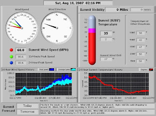
Above is the actual data posted at the time we were at the summit. Wind speed was 68 mph. Insane. Gusting up to 80 mph? Double insane. That's hurricane force winds. Not to mention the temperature of 35 with windchill of 17. Summit visibility? 0. Excellent. Not on the picture was the humidity, which was 100%. You would have to be insane to hike in that kind of weather!
People that came up from the Cog or Auto Rd are stepping into the area where I am after getting off a shuttle and complaining how cold and nasty it is outside! Buddy, you were outside for 2 seconds!!! I just hiked up here!!! See me? I'm still shaking from the cold!!! Other people who managed to hike up as well are purchasing one way cog railway tickets to go back down or trying to get on one of the shuttles!
We have to finish what we started though, so we are hiking all the way back down. First though, we have to buy some more gear because all our old stuff is soaked. My gloves and hat are useless so I have to buy new wool gloves and a wool hat. My Dad does the same but also has to buy a new jacket. We also buy ponchos. Needless to say, the gloves/hat are now staying in my pack, and I will be putting everything in plastic bags so that they don't get wet again. (Walking through fog with 100% humidity doesn't help things either). We know that the worst is over, and that as we descend the weather can only get better and warmer. We leave around 3:15 and start the long journey down the mountain.
This time we have pants and wool gloves and hats and are relatively dry. We are rested, but the cold has sapped some our energy, and after a 4.5 mile hike up the mountain, most people are tired regardless of the weather. We were originally going to take the Gulfside trail to the Jewell trail down, which is a lot less steep, but a little longer at 5.1 miles with total a descent of 3900 ft. However, because of the 68 mph winds, we had to modify our plans a little. The gulfside trail actually travels along side a cliff and is a little bit dangerous because of the very, very strong winds. So, the park ranger suggest we cut that bit out of the hike. What we will do is travel down the way we came up until we come to the Junction for the Gulfside trail. We will follow that trail till it crosses the Cog railway, follow the rail down until it intersects with the Gulfside trail again, then follow that until it turns into the Jewell and take that all the way back down. This will cut out the crazy winds on the cliff (and North side of the Mountain coming off the summit).
Coming out of the summit building, I'm nearly blown off my feet again as my Dad takes a picture of me. (I go without glasses again) We travel back the way we came and the wind this time was coming at us, attempting to push us back up the mountain. Luckily, the hail had stopped and visibility was a tad bit better. It was still crazy just trying to get down the summit "cone" and to the first junction. The difference in wind just from getting off the cone to the first trail junction was incredible. The distance was less than half a mile and a hundred feet down.
We make it the cog and follow that down on a clear dirt path where they are supposedly building new power lines or something. This is not bad, expect for the fact that the wind is still blowing in our face. At several points we can hear and smell the cog, but can never see it, because its still too foggy. We follow the cog for a bit before we pick up the Gulfside trail again. This trail is really rocky, so we have to go back to climbing down with hands and feet. We are not rushing at this point, but keeping up a good pace. Well, it is actually a fairly slow pace. We are both getting tired and sore. My hips hurt at first, but then it is my knees as well as my shoulders. (Carrying lots of wet clothes is not good) My dad says his knees and back hurt. We finally make it the Jewell trail and the treeline, which finally means respite from the wind (and me being able to put my glasses back on). What a difference trees make! The Jewell at this point starts doing this switchback kind of thing, which we don't really like, but it turns out the trail is a lot less steep than the one we came up.
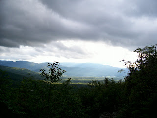
Finally, around five, the fog clears out for the first time all day and you can see the valley! The picture above is one I took for the few mins the fog cleared out. You can actually see that the fog and clouds still surround everything except for that patch of sunlight-an amazing sight! Well, we continue to climb down, it is not much warmer down here, but it is not as windy either. I wear my gloves and hat for most of the summit down.
The trail doesn't seem to end though, it is getting close to 7pm, which means almost 10 hours of hiking! At one point I see a worn sign that looks like it says Couger R., which I take to mean couger rock (which I don't remember being on the map), and we ignore it and keep on going on the trail for what seems like forever. Finally I see a sign that says "base station .3 miles". I end up getting a second wind and power walk the longest .3 miles in my life and finally make it to the road!! Wait, this is not the parking lot! We then proceed to walk an extra 15 mins to our car as the sun sets.
Did you figure out what Couger Rock was? It was a sign for Cog Railway I suspect. The sign was so worn that I couldn't make it out! If we had took that side trail we would have saved an hour! Bummer!!!
Regardless, the entire trip turned out to be 10 hours and 46 mins! About 9.6 miles distance, and total elevation ascended around 3960 ft. In the end, we made it to the top and back, fighting below freezing temperatures, hurricane force winds, hail, and hypothermia, and conquering the majestic and dangerous Mt. Washington.
We made it back to the Motel, ate a nice warm meal, and relaxed in the jacuzzi (which really helped) and slept good that night!!
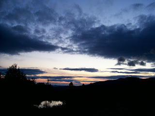
Here's some pics as the day ended: